
 Tappa
02 Tappa
02 
Per la seconda tappa del World Tour 2006 attraversiamo la Manica per portarci a Londra. Lo scenario di
Stansted di John Young č nato per FS2002 ma funziona perfettamente anche in FS2004 ed č
anche molto carino. Anche le procedure SID e STAR di questo aeroporto britannico sono
molto interessanti e divertenti.
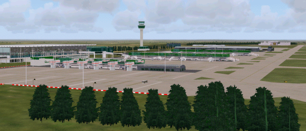
London Stansted
|
Dati Aeroporti (from IVAO)
Paris / Orly
| ICAO-code |
LFPO |
| IATA-code |
ORY |
| Region |
Paris FIR France (LFFF) |
| Coordinates |
N 48° 43' 31" - E 2°
21' 34" |
| Elevation |
291 ft / 89 m |
| Magnetic Variation |
2,029° West |
| Transition Altitude (TA) |
4000 ft |
London / Stansted
| ICAO-code |
EGSS |
| IATA-code |
STN |
| Region |
London FIR UK (EGTT) |
| Coordinates |
N 51° 53' 6" - E 0° 14' 6" |
| Elevation |
348 ft / 106 m |
| Magnetic Variation |
3,316° West |
| Transition Altitude (TA) |
6000 ft |
| Official Website |
http://www.baa.com/main/airports/stansted/ |
Chart
Carte per gli
aeroporti francesi AIP
FRANCE
UK Aeronautical Information Service (AIS)
(Richiede registrazione gratuita)
In alternativa qualcosa si trova anche qui LONDON CENTER e nei piani
Scenari
Scenario Orly FSFrance
Scenario EGGS from Flightsim
cercare il file egssjy5.zip
Piani di Volo
| Formato FS9/FSNAV |
Formato testo |
| piani
tappa |
LFPO SID OPALE UT425
ABUDA UT427 GUBAR UM733 GURLU STAR EGSS |


|